How Remote Sensing Enables Large-Scale Environmental Monitoring

Monitoring the Environment at Scale
Environmental monitoring has traditionally relied on field surveys, manual observations, and site-based assessments to understand ecosystem conditions. These methods remain important, but they are limited when environmental change must be tracked across large landscapes, infrastructure networks, supply-chain regions, or conservation portfolios.
Today, environmental risks are becoming more dynamic. Deforestation, land degradation, urban expansion, heat stress, flooding, and water scarcity are affecting ecosystems and business operations at the same time. For companies and investors, this is not only an environmental concern. It can influence operational continuity, asset resilience, regulatory exposure, supply-chain stability, and long-term financial performance.
This is why remote sensing has become a critical part of environmental intelligence. It allows organisations to monitor change continuously across large areas and convert environmental data into decision-useful insights.
What Remote Sensing Means
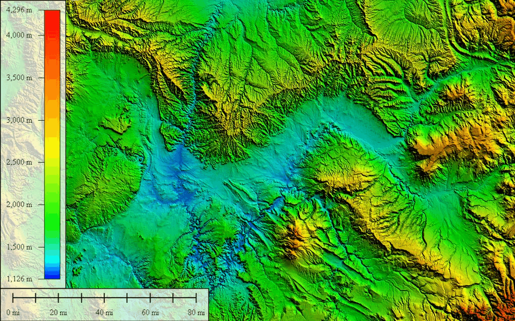
Remote sensing refers to the collection of environmental data without direct physical contact with the landscape being monitored. This is usually done through satellites, drones, aerial systems, and sensor-based imaging technologies.
Satellite platforms such as NASA Earth Observation capture data on vegetation, land cover, water systems, temperature, and atmospheric conditions. This allows organisations to observe environmental patterns across regions and track how they change over time.
Remote sensing is often associated with mapping, but its value extends far beyond static visualisation. While a map provides a snapshot of a landscape at a specific point in time, continuous remote sensing enables organisations to observe how environmental conditions evolve over time. This makes it particularly useful for monitoring ecosystem health, climate exposure, land-use pressure, and environmental risk across large areas.
Why Large-Scale Monitoring Matters
Environmental challenges rarely stay within one project boundary. Forest fragmentation, water stress, land degradation, heat exposure, and biodiversity loss often affect entire landscapes.
Field-based monitoring can provide detailed site-level insights, but it becomes difficult and expensive to scale across thousands of hectares or multiple assets. Remote sensing helps address this by offering wide coverage, frequent observations, and consistent data across locations.
This is especially useful for organisations managing:
- Infrastructure networks
- Industrial assets
- Conservation portfolios
- Renewable energy sites
- Supply-chain landscapes
- Restoration and land-use projects
For businesses, this enables portfolio-level monitoring. Instead of checking one site at a time, organisations can compare risks and environmental performance across multiple locations.
What Remote Sensing Can Measure
Modern remote sensing systems can measure a wide range of environmental, ecosystem health, and climate-risk indicators. These indicators help organisations understand land-use dynamics, habitat condition, vegetation stress, water availability, and exposure to environmental hazards.
Common applications include:
- Tracking vegetation health using NDVI
- Assessing water availability using NDWI
- Monitoring deforestation and habitat fragmentation
- Detecting urban expansion and land-use conversion
- Measuring Land Surface Temperature (LST) and heat stress
- Identifying habitat connectivity and ecosystem condition
- Mapping flood-prone areas and climate-risk hotspots
- Analysing fragmentation metrics across landscapes
Together, these indicators show how landscapes are changing over time. For example, NDVI can reveal vegetation stress, NDWI can indicate changes in water availability, LST can highlight heat exposure, and habitat connectivity metrics can show whether ecosystems are becoming more connected or fragmented.
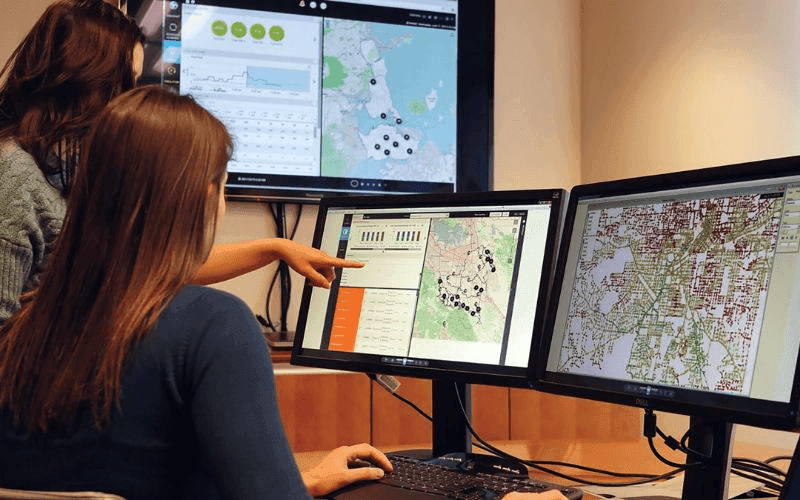
From Satellite Data to Environmental Intelligence
Satellite imagery provides valuable environmental observations, but on its own it rarely supports decision-making. The real value of remote sensing lies in converting raw imagery into environmental intelligence that helps organisations understand where change is occurring, what is driving that change, and how it may affect ecosystems, assets, or operations.
This process combines geospatial analytics, AI, and spatial modelling to identify patterns, detect environmental change, locate hotspots, and classify risk across landscapes.
The process generally includes:
- Collecting satellite or aerial imagery
- Processing and standardising datasets
- Applying spatial models and AI-based analysis
- Detecting change, hotspots, and risk zones
- Generating insights linked to environmental risks and ecosystem change
This transformation from imagery to intelligence makes remote sensing operationally useful for monitoring, planning, and risk management.
Combining Remote Sensing with Ground Data
Remote sensing provides large-scale visibility, but field observations remain essential for validation and interpretation. Satellite imagery may indicate declining vegetation health, for example, but ground-level assessments help determine whether the underlying cause is drought, disease, soil degradation, or land-use pressure.
Validation improves confidence in analytical outputs and reduces uncertainty. The most effective monitoring systems integrate satellite observations with field surveys, sensor-based monitoring, and ecological assessments to create a more complete understanding of environmental conditions.
The Darukaa Perspective
From Darukaa’s perspective, remote sensing is not simply a mapping tool. It is a foundational layer for building continuous environmental intelligence systems that connect landscape change with operational and investment decisions.
Darukaa integrates satellite analytics, geospatial intelligence, bioacoustic monitoring, environmental sensors, climate datasets, and field validation into a multi-layered system. Geospatial intelligence strengthens this by enabling spatial risk mapping, asset-level exposure analysis, habitat fragmentation analysis, and ecosystem boundary delineation.
Time-series monitoring adds another critical layer. It allows organisations to track temporal change, long-term ecosystem evolution, and trend-based risk patterns across sites and landscapes. This helps identify whether vegetation health is improving, water stress is increasing, or habitat conditions are degrading over time.
The system also supports MRV and reporting readiness by creating measurable environmental indicators, validation-ready workflows, and audit-ready monitoring datasets. This makes remote sensing more useful for ESG reporting, nature-related disclosures, restoration verification, and environmental impact tracking.
Most importantly, these insights support action. They help organisations prioritise sites, plan climate-risk mitigation, guide restoration strategies, and make more informed sustainability investment decisions.
Why Businesses and Investors Are Using Remote Sensing
Remote sensing is increasingly relevant for businesses and investors because environmental change can become financial exposure. Land degradation, flooding, heat stress, water scarcity, and habitat loss can affect project performance, asset value, regulatory approvals, and supply chains.
Remote sensing helps organisations:
- Monitor environmental risks across supply chains
- Assess climate exposure across assets
- Track restoration and sustainability initiatives
- Improve ESG and nature-related reporting
- Identify long-term environmental exposure
For investors, this data can support resilience assessment and help identify stranded asset risk. Assets exposed to chronic heat, flood risk, or land degradation may face higher costs and lower long-term value.
Frameworks such as the Taskforce on Nature-related Financial Disclosures are increasing demand for measurable, location-specific environmental data. Remote sensing provides one of the strongest ways to generate that data at scale.
From Monitoring to Decision-Making
One of the most significant advantages of remote sensing is its ability to support decision-making rather than simply observation. Continuous monitoring allows organisations to identify environmental changes early, understand emerging risks, and respond before those risks become more severe.
For example, declining vegetation health across a restoration site may indicate the need for targeted intervention, while flood-risk hotspot detection can inform infrastructure resilience planning. Time-series analysis can also reveal whether restoration activities are improving ecosystem conditions or whether degradation continues despite intervention efforts.
This enables organisations to allocate resources more effectively, monitor environmental performance, and strengthen long-term sustainability planning. In this way, remote sensing becomes part of a broader decision-support system rather than a standalone monitoring tool.
The Future of Environmental Monitoring
The future of environmental monitoring lies in integrated intelligence systems that combine remote sensing with geospatial analytics, climate modelling, biodiversity monitoring, field surveys, environmental sensors, and acoustic data. This integration enables organisations to move beyond isolated observations and develop a more comprehensive understanding of environmental change.
Remote sensing is becoming increasingly valuable for monitoring heat exposure, vegetation stress, water availability, flood-prone areas, and land-use transitions over time. When combined with complementary datasets, it supports continuous ecosystem monitoring, strengthens risk assessment, improves impact measurement, and enables more informed decision-making.
FAQs
1. What is remote sensing in environmental monitoring?
Remote sensing collects environmental data using satellites, drones, and aerial technologies without direct contact with the ground.
2. Why is remote sensing important?
It enables continuous and large-scale monitoring of ecosystems, land-use changes, and environmental risks.
3. What can remote sensing measure?
It can track vegetation health, water systems, temperature, land-use changes, and habitat conditions.
4. What is NDVI in remote sensing?
NDVI is a vegetation index used to measure plant health and ecosystem productivity.
5. How does AI improve remote sensing?
AI helps analyse large satellite datasets to detect environmental patterns and changes more efficiently.
6. Can remote sensing replace field surveys?
No, it complements field surveys by providing large-scale visibility and continuous monitoring.
7. How does remote sensing support ESG reporting?
It provides measurable and verifiable environmental data for sustainability disclosures and reporting.
8. Why are businesses using remote sensing?
Businesses use it to assess environmental risks, monitor supply chains, and track sustainability initiatives.
9. Can remote sensing monitor biodiversity?
Yes, it helps track habitat changes, vegetation health, and ecosystem conditions linked to biodiversity.
10. How does Darukaa use remote sensing?
Darukaa integrates remote sensing with biodiversity and climate data to deliver continuous environmental intelligence.