Multi-modal Evidence: The Next Benchmark in Ecology Monitoring
Ecological Monitoring Is Moving Beyond One Method
Ecological monitoring uses a range of methods, including field surveys, camera traps, bioacoustics, eDNA, remote sensing, and environmental sensors. Each method captures a different part of ecosystem condition, from species presence and activity to habitat quality and landscape change.
Modern monitoring is increasingly moving toward integrated evidence systems that combine these methods rather than relying on one source alone. This creates a more complete, measurable, and scientifically robust understanding of biodiversity across space and time.
This shift toward multi-modal evidence allows ecological observations to be interpreted together, helping organisations build stronger confidence in ecosystem trends, restoration outcomes, and nature-related risk assessment.
What Multi-modal Evidence Means
Multi-modal evidence integrates multiple sources of ecological data to provide a more comprehensive understanding of biodiversity and ecosystem change. These include bioacoustics, camera traps, environmental DNA (eDNA), remote sensing, environmental sensors, and field observations. Each method captures different ecological signals, helping organisations understand species presence, activity, habitat conditions, and environmental changes that may not be visible through a single monitoring approach.
Each monitoring approach contributes a different perspective:
- Bioacoustics helps understand species activity through ecosystem soundscapes.
- Camera traps provide visual evidence of wildlife presence and behaviour.
- eDNA detects species that may be rare, hidden, aquatic, or otherwise difficult to observe.
- Remote sensing tracks vegetation condition, habitat quality, land-use change, and climate-related indicators.
- Environmental sensors measure conditions such as temperature, humidity, soil moisture, and water quality.
- Field observations validate monitoring outputs and provide ecological interpretation.
The value of multi-modal evidence lies in combining these complementary observations rather than relying on any single method. When different data sources reveal consistent ecological patterns, they strengthen interpretation, reduce uncertainty, and provide a more reliable understanding of ecosystem conditions over time. This integrated approach supports biodiversity assessments, restoration monitoring, biodiversity credits, nature-related disclosures, and evidence-based environmental decision-making.
Why Single-method Monitoring Falls Short
The biggest challenge in ecological monitoring is not always the lack of data, but the difficulty of connecting different observations into a reliable understanding of ecosystem health. When evidence is collected or analysed in isolation, important ecological patterns can remain unnoticed, making it difficult to interpret changes accurately.
For example, an increase in vegetation cover may indicate successful restoration, but it does not necessarily confirm improvements in biodiversity. Understanding whether an ecosystem is genuinely recovering requires evidence of species presence, habitat use, and ecological conditions alongside changes in vegetation.
Fragmented ecological evidence creates three key challenges:
- Incomplete species detection: Important species and ecological interactions may go undetected, resulting in an incomplete picture of biodiversity.
- Difficulty validating ecological change: Without supporting observations, it becomes harder to determine whether changes represent genuine ecological improvement, seasonal variation, or temporary fluctuations.
- Uncertainty in restoration outcomes: Limited evidence makes it difficult to assess whether restoration interventions are delivering measurable and sustained biodiversity improvements.
These challenges become particularly significant when monitoring results are used to verify restoration outcomes, support biodiversity claims, or assess nature-related risks. The quality of ecological decisions depends not only on the data collected, but on how effectively different observations are connected, interpreted, and validated.
How the Methods Complement Each Other
The strength of multi-modal ecology monitoring lies in how different sources of evidence work together to explain ecosystem conditions. Rather than analysing species presence, activity, and habitat changes separately, an integrated approach connects these observations to develop a more reliable understanding of biodiversity and ecological recovery.
Consider a degraded forest undergoing restoration. Satellite imagery may reveal increasing vegetation cover and improving habitat conditions over time. However, vegetation growth alone cannot confirm whether the ecosystem is recovering its biodiversity or supporting wildlife.
This is where complementary monitoring methods become valuable. Bioacoustic recordings can reveal changes in bird and insect activity, while camera traps provide evidence of wildlife movement and habitat use. Environmental DNA (eDNA) sampling may identify aquatic or difficult-to-observe species in nearby water bodies, adding another layer of biodiversity information. Field ecologists can then examine these findings together, validate observations, and assess whether the changes indicate genuine ecological recovery.
The value comes from connecting these findings:
- Habitat recovery: Remote sensing identifies changes in vegetation cover and landscape conditions.
- Species response: Bioacoustics, camera traps, and eDNA provide complementary evidence of species presence, activity, and habitat use.
- Ecological validation: Field observations help determine whether these signals reflect meaningful biodiversity improvements.
- Long-term monitoring: Repeated measurements reveal whether positive changes are sustained across seasons and monitoring cycles.
For example, increasing vegetation cover alongside greater bird activity and more frequent wildlife detections may provide stronger evidence of restoration progress than vegetation measurements alone. However, these patterns must still be interpreted against baseline conditions, seasonal variation, and consistent monitoring methods.
By bringing these observations together, organisations can move beyond tracking isolated environmental indicators to understanding how ecosystems respond to restoration interventions. This creates a stronger evidence base for evaluating biodiversity outcomes, identifying areas that need further intervention, and making informed ecological management decisions.
From Data Layers to Evidence Systems
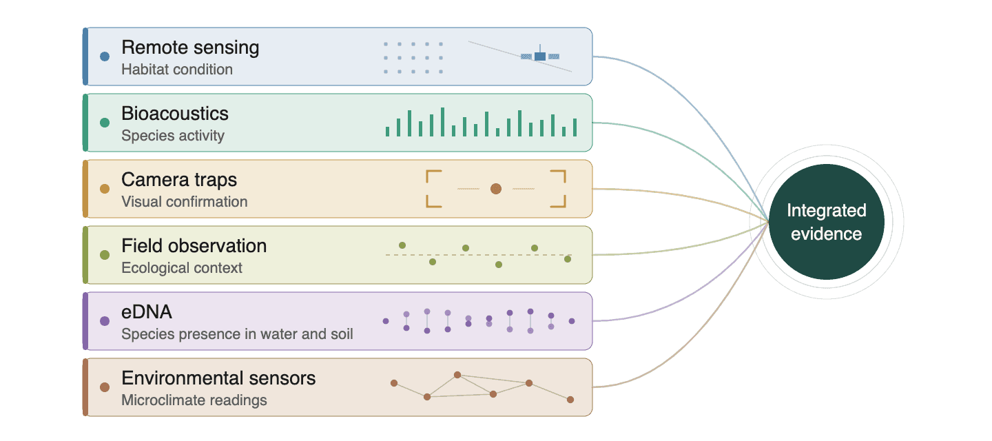
The future of ecology monitoring is not defined by the volume of data collected, but by the ability to integrate different sources of ecological evidence into a coherent monitoring system. Combining multiple monitoring methods allows organisations to understand not only which species are present, but also how ecosystems are functioning and changing over time.
A comprehensive evidence system brings together multiple ecological layers, including:
- Species presence identified through eDNA
- Species activity recorded through bioacoustics
- Visual confirmation from camera traps
- Habitat condition derived from remote sensing
- Ecological interpretation through field observations
- Environmental conditions measured by in-situ sensors
When analysed together, these complementary datasets provide stronger evidence of ecosystem condition and improve confidence in long-term ecological trends. Repeated observations further strengthen monitoring by showing whether biodiversity indicators are improving, declining, or remaining stable across multiple monitoring cycles.
For example, remote sensing may indicate increasing vegetation cover within a restoration site, bioacoustics may record greater bird and insect activity, and eDNA may detect the return of native aquatic species. Field teams can then validate whether these independent signals collectively represent genuine ecological recovery rather than isolated observations.
Multi-modal Evidence and Verification
As biodiversity monitoring becomes linked to carbon projects, biodiversity credits, ESG reporting, and nature-related disclosures, evidence quality becomes critical. Claims about ecological improvement must be measurable, traceable, and verifiable.
Multi-modal evidence supports this by creating multiple lines of proof. A restoration project can show vegetation recovery through satellite data, species activity through soundscapes, hidden biodiversity through eDNA, and field validation through ecological surveys.
This is especially important for digital MRV. Audit-ready monitoring depends not only on data collection, but also on standardised methods, clear chain of custody, and traceable records. Each dataset should show where it was collected, when it was collected, how it was processed, and how it was validated.
A single dataset may be questioned, but multiple complementary datasets create stronger confidence. When bioacoustic records, camera trap images, eDNA samples, satellite layers, and field observations are standardised and linked together, they create a more auditable evidence trail.
This strengthens verification by improving transparency, reducing uncertainty, and making biodiversity outcomes easier to review, compare, and report.
Role of Geospatial Intelligence
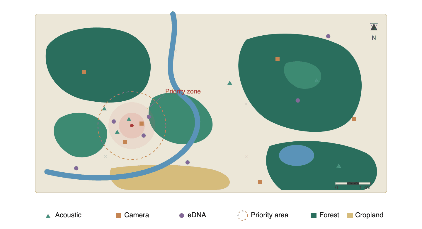
Geospatial intelligence connects ecological evidence to place. It helps map where biodiversity signals are found, how habitats are changing, and where ecosystem risks are concentrated.
This is important because ecology is location-specific. A species detection becomes more meaningful when it is linked to habitat type, habitat connectivity, fragmentation, water availability, land-use change, and climate exposure. Geospatial data helps create this context.
It can support:
- Habitat connectivity analysis to understand how species may move across landscapes
- Biodiversity hotspot mapping to identify areas of high ecological value
- Ecosystem boundary delineation to define monitoring zones clearly
- Spatial risk assessment to locate areas exposed to degradation, disturbance, or climate stress
For example, acoustic activity may decline in one part of a site. Remote sensing may show vegetation stress or habitat fragmentation in the same zone. Camera traps may show reduced wildlife movement. Together, these signals can identify a priority area for restoration or mitigation.
Geospatial intelligence also supports portfolio-level monitoring. Organisations managing multiple sites can compare ecosystem conditions, risk distribution, and biodiversity performance across landscapes.
The Darukaa Perspective
At Darukaa, multi-modal evidence represents the foundation of environmental intelligence because no single monitoring method can fully capture ecosystem complexity. Biodiversity is expressed through multiple ecological signals, and meaningful environmental insights emerge when those signals are interpreted together within their spatial, temporal, and ecological context.
Darukaa integrates bioacoustics, camera traps, eDNA, remote sensing, environmental sensors, geospatial intelligence, and field validation into a unified biodiversity intelligence framework. Bioacoustics captures species activity, camera traps provide visual confirmation, eDNA reveals hidden biodiversity, remote sensing monitors habitat dynamics and landscape change, while environmental sensors and field observations strengthen ecological interpretation and validation.
Geospatial intelligence connects these diverse datasets by mapping habitat quality, ecosystem connectivity, fragmentation, biodiversity hotspots, and site-level ecological risks. Continuous time-series analysis further enables organisations to monitor biodiversity trends, ecosystem trajectories, restoration progress, and environmental change across seasons and years.
The result is a continuously updated environmental intelligence system that supports restoration planning, biodiversity impact assessment, digital MRV, TNFD-aligned reporting, and nature-related risk management. By integrating multiple independent sources of ecological evidence, organisations gain stronger confidence in biodiversity outcomes while improving the credibility, transparency, and traceability of environmental reporting.
From Ecological Signals to Decision Intelligence
Multi-modal monitoring delivers its greatest value when ecological observations are translated into practical decisions. Each monitoring method contributes different evidence, but meaningful environmental intelligence emerges when these independent signals are interpreted together to understand ecosystem condition, biodiversity risk, and restoration progress.
For example, a restoration site may simultaneously demonstrate increasing acoustic diversity, improving vegetation condition derived from satellite observations, and growing detections of native species through eDNA across multiple monitoring cycles. Together, these independent indicators provide stronger evidence that restoration activities are improving ecosystem health and help guide future management decisions.
Conversely, declining acoustic activity, increasing habitat fragmentation, and reduced wildlife detections from camera traps may collectively indicate ecosystem stress. Identifying these patterns early enables organisations to prioritise field investigations, restoration planning, habitat management, and mitigation measures before ecological degradation becomes more severe.
Rather than functioning as isolated datasets, integrated ecological signals become a decision-support system that strengthens biodiversity impact assessment, restoration verification, nature-related risk management, and long-term environmental planning.
Why It Matters for Business and Policy
Businesses and investors are increasingly expected to understand how their operations affect biodiversity and how ecosystem health affects long-term performance. Frameworks such as the Taskforce on Nature-related Financial Disclosures are increasing demand for decision-useful nature data.
Multi-modal evidence helps meet this demand. It provides stronger, more credible, and more complete biodiversity information than any single method can provide alone.
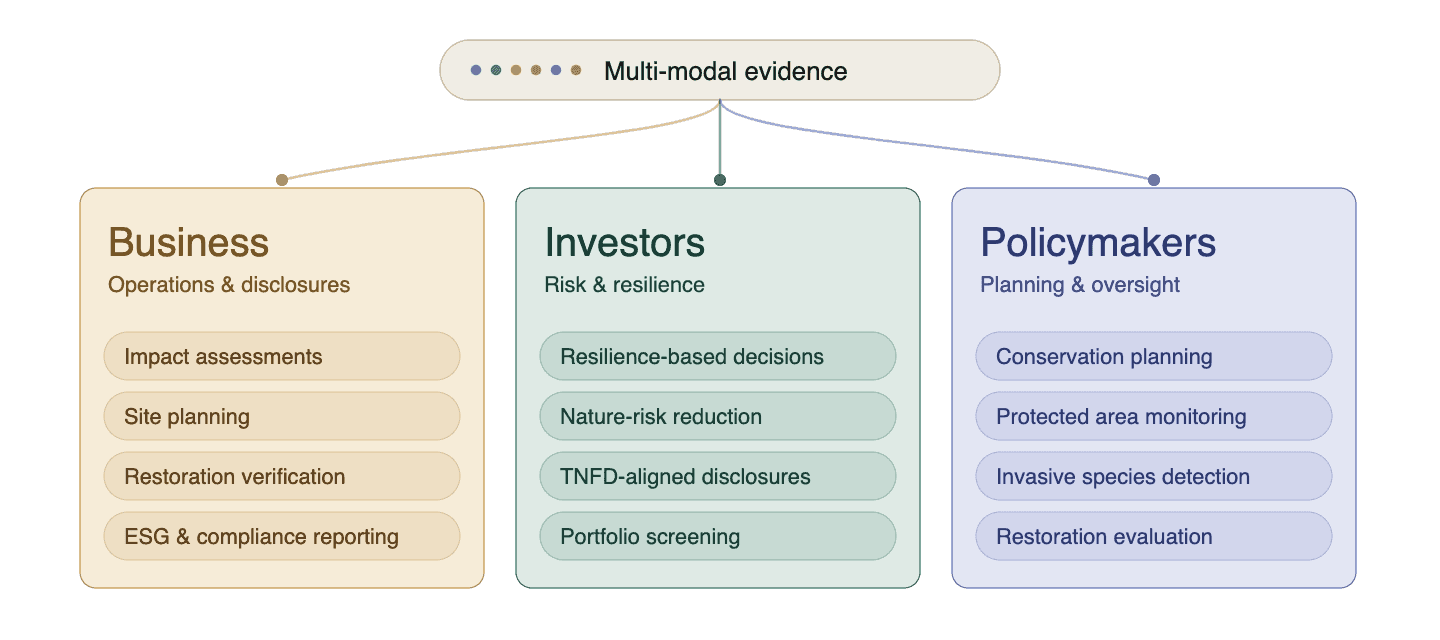
For businesses, this can support biodiversity impact assessments, site planning, restoration verification, compliance readiness, and ESG reporting. For investors, it can support resilience-based investment decisions and reduce uncertainty around nature-related risks.
For policymakers, multi-modal evidence can improve conservation planning, protected area monitoring, invasive species detection, and restoration program evaluation.
The Way Forward
The future of ecology monitoring will not be defined by any single technology, but by the ability to integrate complementary sources of ecological evidence into continuous and scientifically robust monitoring systems. Bioacoustics, camera traps, eDNA, remote sensing, environmental sensors, and field observations each contribute unique insights that become significantly more valuable when analysed together.
As biodiversity reporting, restoration verification, and nature-related risk assessment continue to evolve, organisations will increasingly require monitoring systems that are measurable, transparent, and capable of generating audit-ready evidence. Multi-modal evidence provides the foundation for this next generation of biodiversity monitoring by combining multiple ecological signals into reliable environmental intelligence that supports stronger decisions, more credible reporting, and better long-term conservation outcomes.
FAQs
1. What is multi-modal evidence in ecology monitoring?
Multi-modal evidence combines data from bioacoustics, camera traps, eDNA, remote sensing, and field observations to understand ecosystems more completely.
2. Why is multi-modal monitoring important?
It reduces blind spots by combining complementary methods that capture species presence, activity, behaviour, and habitat condition.
3. How does bioacoustics support ecology monitoring?
Bioacoustics records ecosystem soundscapes to detect species activity, acoustic diversity, and changes in biodiversity over time.
4. What role do camera traps play?
Camera traps provide visual evidence of wildlife presence, behaviour, movement, and habitat use.
5. How does eDNA help biodiversity monitoring?
eDNA detects genetic traces left in water, soil, air, or sediment, helping identify hidden, rare, or hard-to-observe species.
6. Why is remote sensing useful?
Remote sensing tracks vegetation health, habitat fragmentation, land-use change, water stress, and climate-related indicators at large scales.
7. Why are field observations still needed?
Field observations validate digital signals, provide ecological interpretation, and reduce uncertainty in monitoring results.
8. How does multi-modal evidence support MRV?
It creates multiple traceable evidence layers that strengthen measurement, reporting, verification, and audit-ready biodiversity monitoring.
9. How does this help businesses?
It supports biodiversity impact assessments, risk identification, restoration validation, compliance, and sustainability reporting.
10. How does Darukaa use multi-modal evidence?
Darukaa integrates bioacoustics, camera traps, eDNA, remote sensing, sensors, and field data into biodiversity intelligence systems.